Tennessee is known as the most biologically diverse inland state in the country. Part of what makes it so diverse is the many types of habitats, ecosystems, and species found throughout the state. There are more than 60,000 miles of streams and rivers flowing across Tennessee, home to more than a thousand species of fish, amphibians, mussels, and more.
What is a River?
A river or stream is a flowing channel of water on the surface of the land. While there is no exact differentiation between the rivers and streams, larger channels tend to be labeled as rivers and smaller channels are labeled as streams or creeks. However, a river or stream actually consists of more than just the channel.
Rivers and streams need to be considered in the larger context of their floodplains, which are typically defined as the area on either side of the channel that floods annually. This annual flooding is critical to the health, flow, and functions of rivers and streams. Wetlands, floodplain forests, sloughs and other features, like vegetation, all contribute to ensuring that rivers and stream channels maintain clean water by trapping nutrients and sediments. And they also provide public benefits like flood control, groundwater recharge and important fish and wildlife habitat.
Rivers can be classified in many ways, such as the percent of time the river is flowing. A river is perennial if water flows all the time; it is ephemeral if it flows after heavy rainfall; and it is intermittent if it flows constantly during the wet season but only after heavy rain during the dry season. Rivers can also be classified based on the substrate beneath the water. An alluvial river flows on a bed of sediment that it continues to transport downstream, whereas a non-alluvial river flows directly on bedrock.
Additionally, rivers and streams are often characterized by their morphology by using scientifically generated classification systems. One such widely used system is the Rosgen stream classification system. This system not only classifies rivers and streams, it helps restoration practitioners ensure a river or stream meets the desired habitat objectives within the landscape.
Rosgen Classification of Channels
The Rosgen system of classifying stream channels is based on several factors, including valley type, slope of the bank, soil type and sedimentation, and curvature of the channel.
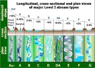
Type A Channels
- Found in steep-sloping, mountainous environments
- Type Aa+: Steeper slopes (>10% grade)
- Type A: Slopes of 4-10%
- Characteristics: Narrow, straight channels with step/pool formations from large rocks and debris. Rarely flood beyond the stream bank and lack well-developed floodplains.
Type B Channels
- Occur on moderate slopes (2-4%)
- Characteristics: Relatively straight; shorter and more stable banks than Type A channels; resistant to watershed changes causing erosion. Rapids are common.
Type C Channels
- Shallow, meandering channels of varying width
- Characteristics: Low sloping (<2%), containing many natural riffles. Well-developed floodplains, but channel stability depends on water flow, sediment composition, and bank characteristics.
Type D Channels
- Contain three or more braided channels.
- Type D: Wide and shallow with eroding banks
- Type DA: Narrow and deep with well-vegetated, stable banks.
Type E Channels
- Often develop within former Type F channel beds that have become vegetated.
- Represent the evolutionary end point of stream morphology and equilibrium.
- Characteristics: Narrow and deep with a very wide and well-developed floodplain.
Type F Channels
- Classic deep, meandering rivers, typically forming new floodplains at lower elevations.
- Characteristics: High bank erosion rates; evolve into Type C or E channels
Type G Channels (Gullies)
- Similar to Type F but narrower and occurring on steeper slopes (2-4%)
- Characteristics: High erosion rates; often widen into Type F channels
Understanding a river channel’s characteristics is crucial for monitoring the health of rivers and streams, and for developing restoration plans where they have been damaged. These classifications serve as the starting point for river assessment. Once the channel type is identified, further measurements and evaluations can predict the river’s behavior and the potential impacts of heavy rainfall, landscape changes, and other modifications to the river or floodplain.
Sources:
- Jennings, G. and Harman, W. (1999, August 1). Application of the Rosgen Stream Classification to North Carolina. NC State Extension. Retrieved June 7, 2024. Link
- Rosgen, D. L. (1994). A classification of natural rivers. CATENA, 22(3), 169-199. Link
- Southard, J. (2021, December 25). “5.6: Classifying Rivers.” The Environment of the Earth’s Surface. Massachusetts Institute of Technology. Retrieved June 7, 2024. Link
- U.S. Environmental Protection Agency. (n.d.). Fundamentals of Rosgen Stream Classification System. Watershed Academy Web. Retrieved June 7, 2024. Link
- Water Science School. (2018, June 6). Rivers, Streams, and Creeks. U.S. Geological Survey. Retrieved June 7, 2024. Link
Featured photo by Scott Brooks